
GRIEKENLAND - GREECE
 Griekenland, ook wel bekend als Hellas en officieel de Helleense Republiek (Ellhnikh Dhmokratia), is een land in het meest zuidelijke deel van Europa. Gelegen op het zuidelijke einde van het Balkan-schiereiland. Het land heeft grenzen met Albanië, de Republiek Macedonië, Bulgarije in het noorden en het oosten van Turkije.De Egeïsche Zee ligt ten oosten van het vasteland van Griekenland, de Ionische Zee ten westen en de Middellandse Zee ten zuiden. Griekenland is een strategisch kruispunt tussen het Oosten en het Westen.Griekenland heeft een lange kustlijn van wel 14.880 km lengte en is daarmee tiende in de wereldranglijst in de wereld. Grienland heeft een groot aantal eilanden (ongeveer
  1400, 227 zijn bewoond), inclusief Kreta, de Dodekanesos, de Cycladen en de Ionische eilanden.Tachtig procent van Griekenland bestaat uit bergen, waarvan de hoogste, de berg Olympus is (2917m). Het moderne Griekenland heeft zijn wortels in de beschaving van het oude Griekenland, een cultureel erfgoed van 4000 jaar oud. In het algemeen beschouwd als de bakermat van de westerse beschaving. Zo komt het dat Griekenland aanzien word als geboorteplaats van de democratie, de westerse filosofie, de Olympische Spelen, Westerse literatuur en geschiedschrijving, politieke wetenschappen, belangrijke wetenschappelijke en wiskundige principes en West-drama met inbegrip van zowel tragedie en komedie. Griekenland is een ontwikkeld land met een zeer hoge menselijke ontwikkeling. Griekenland is lid van de Europese Unie sinds 1981. Athene is de hoofdstad. Andere zéér gekende steden zijn Thessaloniki, Pireaus, Patras, Heraklion en Larissa. Ondanks zijn kleine oppervlakte, heeft Griekenland een bijzonder rijke natuurlijke omgeving, een zeldzame geomorfologie van scherpe contrasten en vele plaatsen zijn van hoge ecologische waarde. Ingesprongen kustlijnen, de imposante bergen, de grotten en ravijnen, de meren, de rivieren, de biotopen en de unieke ecosystemen, een make-up landschap van uitzonderlijke schoonheid over het gehele land. Een perfecte bestemming voor eco-toerisme. De Griekse keuken is uitermate interessant, het is een van de weinige in de wereld met een grote historische achtergrond, daterende uit de oudheid. De indrukwekkende smaken en een manier van denken dat geeft een bijzondere aandacht aan de gezonde culinaire praktijken.
 Vandaag wordt Griekse keuken beschouwd als een van de meest krachtige ambassadeur in het buitenland. In tijden van vandaag zijn Amerikanen en Europeanen de voordelen aan het ontdekken van de Griekse keuken en het mediterrane lijnen.
Het mediterrane klimaat van Griekenland wordt gekenmerkt door de milde winters, relatief warme droge zomers en in het algemeen langere perioden van de zon het hele jaar door.Greece also know as Hellas and officially the Hellenic Republic (Ellhnikh Dhmokratia), is a country in the most southern part of Europe, situated on the southern end of the Balkan Peninsula. The country has borders with Albania, the Republic of Macedonia and Bulgaria on the north and Turkey to the east. The Aegean Sea lies to the east of the mainland of Greece, the Ionian Sea to the west and the Mediterranean Sea to the south. Greece is a strategic crossroad between the East and the West. Greece has a tenth longest coastline in the world at 14.880 km in length, featuring a vast number of Islands (approximately 1400 of which 227 are inhabited), including Crete, the Dodecanese, the Cyclades, and the Ionian islands among others. Eighty percent of Greece consists of mountains, of which Mount Olympus is the highest at 2917m. Modern Greece traces its roots to the civilisation of Ancient Greece, a cultural heritage of 4000 years old. Generally considered to be the cradle of Western civilisation. As such it is the birthplace of democracy, Western philosophy, the Olympic games, Western literature and historiography, political science, major scientific and mathematical principles and Western drama including both tragedy and comedy. Greece is a developed country with a very high Human Development. Greece has been a member of the European Union since 1981. Athens is the capitol. Other major cities include Thessaloniki, Piraeus, Patras, Heraklion and Larissa. Despite its small area, it has a particularly rich natural environment, a rare geomorphology of sharp contrasts and many places of high ecological value. Indented coastlines, the imposing mountains, the caves and canyons, the lakes, the rivers, the biotopes and the unique ecosystems make-up landscapes of exceptional beauty throughout the country. A prefect destination for eco tourism.
Greek cuisine is of great interest, since it is one of the few in the world with the most history dating back to ancient times, impressive lastingness, and a way of think that gives a special attention tot tastiness an healthy culinary practices. Today Greek cuisine is considered one of the country’s most powerful ambassadors abroad and especially nowadays that both Americans and Europeans are in progress of discovering the advantages of the Mediterranean diet and cooking. The Mediterranean climate of Greece is characterized by mild winters, relatively warm and dry summers and generally extended periods of sunshine throughout the year.
VASTE LAND - MAINLAND
ATHENE- ATHENS

Athene is de historische hoofdstad van Europa. Athene heeft een lange geschiedenis, die dateert uit de eerste nederzetting in het Neolithicum. In de 5 e eeuw voor Christus, (Gouden Eeuw van Pericles) - het hoogtepunt van Athene lange fascinerende geschiedenis - de stad van de waarden en beschaving verworven een universele significatie. Politiek denken, theater, kunst, filosofie, wetenschap, architectuur, onder andere vormen van intellectueel voleinding, uniek in de wereldgeschiedenis. Athene was de schoot van de westerse beschaving. Een gastheer van de Griekse woorden en ideeën, zoals democratie en harmonie, muziek, wiskunde, kunst, de gastronomie, architectuur, logica, eros, euforie, etc. Verrijkt met een veelvoud van veroveraars die Athene hebben bezet, en oprichting van unieke prachtige monumenten - een zeldzame historisch palmares. In 1834 in Athene werd de hoofdstad van de moderne Griekse staat. De keuze was gebaseerd op de symbolische betekenis van Athene klassieke geschiedenis. In twee eeuwen geleden is Athene uitgegroeid tot een aantrekkelijke moderne metropool met een ongeëvenaarde charme. Athene biedt bezoekers een unieke ervaring. Een reis door 6000 jaar geschiedenis, inclusief de kans tot het zien van beroemde monumenten en de meesterwerken, de kunst van de oudheid en de middeleeuwen. En de architecturale erfenis van de 19e en 20e eeuw. Je krijgt een gevoel van behaaglijkheid uplifting in het felle licht van de hemel van Athene, het prachtige landschap in de omgeving van de stad en genieten van de moderne infrastructuur van de stad en van de unieke flair van de Athenias. Athenias is de officieele naam voor de inwoners in Athene.
Athens is the historical capital of Europe. Athens has a long history, dating from the first settlement in the Neolithic age. In the 5 th century before Christ, (Golden age of Pericles) – the culmination of Athens long fascinating history – the city’s values and civilisation acquired a universal significaticance. Political thought, theatre, the arts, philosophy, science, architecture, among other forms of intellectual consummation unique in de world history. Athens was the womb of western civilisation. A host of Greek word and ideas, such as democracy, harmony, music, mathematics, art, gastronomy, architecture, logic, eros, euphoria, among others, enriched a multitude of conquerors occupied Athens, and erected unique splendid monuments – a rare historical palimpsest. In 1834 Athens became the capital of the Modern Greek state. The choice was based on the symbolic significance of Athens classical history. In two centuries since Athens has become an attractive modern metropolis with unrivalled charm. Athens offers visitors a unique experience. A journey in its 6000 years of history, including the chance too see renowned monuments and masterpieces of art of the antiquity and the Middle ages, and the architectural inheritance of the 19th and 20th centuries. You get a uplifting feeling of snugness in brilliant light of the Attric sky, surveying the charming landscape in the environs of the city and enjoying the modern infrastructure of the city and unique verve of the Athenias as the people are called.
Toeristische plekjes - Toeristic attractions
Syntagma Square
 Syntagmaplein is het meest centrale plein van Athene. De naam van het plein is afgeleid van een opstand op 3 september 1843, de mensen en de bewaker van Athene voor de toenmalige Paleis (wat nu het parlementsgebouw is), eisten dat koning Otto een grondwet goedkeurde. Syntagma-plein en Omonia Square zijn de twee centrale locaties van de stad.
 Syntagma Square is Athens central square. The name of the square is derived from an uprising on the 3 th of september 1843, of the people and the guard of Athens before the then Palace building (what's now the parlement), demanding that King Otto grand a Constitution. Syntagma Square and Omonia Square are the two central locations of the city.
  Dominerend op het Syntagma Plein. Het gebouw was de residentie van de eerste koning van Griekenland Koning Otto. Het gebouw werd gebouwd 1836 tot 1842. George A., die er in geslaagd was Otto op de troon te krijgen, verbleef eveneens in het paleis. Tijdens zijn bewind, waren er twee opeenvolgende branden die het gebouw verwoesten, daardoor werd het ongeschikt voor gebruik als een koninklijke residentie. In 1924 werd in het gouvenment besloten om Parlaiment te situeren in het gebouw. De wederopbouw werd voltooid in 1934. Het interieur werd ontworpen door architect een Kriezis. In het parlement vindt u nationaal erfgoed, zoals ook de eerste Griekse grondwet, en een groot aantal waardevolle schilderijen. De bibliotheek is een bezoekje waard. Het doet al sinds het begin van de 20 ste eeuw geen dienst meer als paleis, maar sinds 1935 is het de plek waar het 300 koppen tellende Grieks parlement bijeenkomt.
Dominating Syntagma Square, the building was the residence of the first king Otto. The building was constructed from 1836 to 1842. George A. , who succeeded Otto on the throne, also resided in the palace. During his reign, two successive fires destroyed the building, making it unsuitable for use as a royal residence. In 1924 the gouvenment decided to situate Parlaiment in the building. Reconstruction work was completed in 1934. The interior was redesigned by architect A Kriezis. In Parliament you will find national treasures, such as the first Greek Constitution, and a multitude of valuable paintings. The libary is worth a visit. The building no longer functioned as a palace since the beginning of the 20th century, but since 1935, it is the place where 300 heads constituent Greek parliament meets.
The Presidential Mansion
Situated on Herodou Attikou Street. It is the official residence of the respective Greek prime minister, it was designed in 1924 by Ant.Helmes. The mansion was constructed following the death of Helmes, by his wife, and her new husband D.Maximos. It has a small garden.
National Garden
The National Garden, open from dawn to sunset, is an oasis in the centre of the city. It has a total area of 160000 m2. Some five hunderd different kinds of plants, bushes and trees form various locations around the world are grown here. The National Garden which was formely the palace garden, was laid out from 1838 to 1860. There are four entrances : Vassilis Sophias avenue, Herodou Attikou street, Vassilisis Amalias avenue and an entrance connecting the National Garden to the Zappeion. It is a good place to go for a walk, sit on a bench, listen to the singing of the birds and relax.
Monument of the unknown soldier
 Gebouwd van 1929 tot 1932. Is te vinden tegenover het Parlement, het is een in marmer gebeeldhouwde afbeelding van een gedode soldaat (werk van de beeldhouwer K. Dimitriades), voorzien van een inscriptie met fragmenten van Pericle's Epitaph. Op de marmeren muur rond het monument zijn de grootste veldslagen van het Griekse leger vermeld dit tot het jaartal 1821. Griekse en de bezoekende ambtenaren leggen een krans bij het monument op de nationale feestdagen. Het monument is de klok rond bewaakt door twee elite soldaten.
 Built from 1929-1932 -, in front of the Parliament, it is a sculpted depiction of a slain soldier (work of the sculptor K. Dimitriades), bearing an inscription with excerpts of Pericle's Epitaph. Commemorated on the mable wallsurrounding the monument are the greatest battles of the Greek army posterior to 1821. Greek and visiting officials lay a wreath at the monument on the national holidays. The monument is guarded around the clock by two select troops.
Changing of the Evzone Guards.

De Evzone zijn soldaten die het monument van de onbekende soldaat rond de klok bewaken. De ceremonie van de wisseling van de wacht, dat plaatsvindt elk uur, is de moeite waard.
The Evzones are the guards whom guard the monument of the unkown soldier arround the clock. The ceremony of the changing of the guard, which takes place every hour, is worth seeing.
National garden
De nationale tuin, geopend van zonsopgang tot zonsondergang, een oase in het centrum van de stad. Het heeft een oppervlakte van 160.000 vierkante meter. Het huisvest vijfhonderd verschillende soorten planten, struiken en bomen van verschillende locaties over de hele wereld. De Nationale tuin, die vroeger de tuin van het paleis was, werd aangelegd van 1838 tot 1860. Er zijn vier ingangen. Het is een goede plek voor een wandeling, op een bankje te zitten, te luisteren naar de zingende vogels en te ontspannen. IN de tuin kan je ook een meertje met eenden, de Botanische Museum, een klein traditioneel cafe, een jeugdbibliotheek en een speeltuin vinden voor ieder wat wils.
The national garden, open from dawn to sunset, is an oasis in the centre of the city. It has a totl area of 160.000 square mile. Some five hundred different kinds of plants, bushes and trees from various locations around the world are grown here. The National Garden which was formerly the palace garden, was laid out from 1838 until 1860. There are four entrances. It is a good place to go for a walk, sit on a bench, listen to the singing of the birds and relax. You will find a lake with ducks, the Botanical Museum, a small traditional cafe, a children's library and a playground.
Kapnikarea Church
 De Kapnikarea is een kruisvormige koepelkerk met een koepel gewijd aan de Maagd Maria. Het oorspronkelijke gebouw werd gebouwd in de 11e eeuw. De bouw werd voltooid in de 13e eeuw. Het heeft verschillende namen: Camoucharea, Chryssocamouchariotissa, Panagia tis Vasilopoulas. In 1834, het jaar de aanleg van Ermou Street, hadden de autoriteiten plannen gesmeed om de kerk te slopen of te verplaatsen. Vooral omdat de kerk het gelegen was in het midden van de Ermou Street en het een belemmering was voor het verkeer. Maar dankzij de tussenkomst van Ludwig van Bavaria, de vader van Koning Otto en Neofytos Metaxas, bisschop van Talantino en priester van Athene, werd de kerk bewaard op de huidige locatie.
The Old Metropolis Catherdal
 Deze charmante kerk is gelegen nabij de nieuwe kathedraal. Gebouwd in de late 12de eeuw. Het is gewijd aan Georgoepikoos Panagia en Agios Eleftherios. Oude en Byzantijnse reliëfs werden gebruikt voor de bouw van de kerk. In de gevel is een oude fresco, overgeplaatst uit een monument van de 4de eeuw, de afbeelding toont officiële Athense festiviteiten. De kerk was het officiële bisschoppelijk toevluchtsoord van Athene na de verdrijving van de bisschoppen van het Parthenon door de Franken en later de Turken. Van 1839 tot 1842 werd de cathedraal gebruikt is als een bibliotheek. De nieuwe Metropolis Cathedraal in de buurt werd gebouwd rond 1842 en beëindigd in 1862. In 1862 werd de kerk de kathedraal van Athene. Het is een koepelkerk ingebouwd in Neo-byzantijnse en neoklassieke stijl.


The academy of Athens
 Gebouwd in 1859 beëindigd in 1887. Aan weerszijden van de academie, zijn twee vleugels versierd met fresco's en en een paar hoge zuilen ter ondersteuning van de beelden van Apollo en Athena. De Academie werd bestudeerd door T. Hansen, de jongste van de gebroeders Hansen. De beelden waar gebeeldhouwd door L Drosis. De Academie wordt beschouwd als een uitstekend voorbeeld van de Griekse bouwstijl.
 Built in 1859 untill 1887. On either side of the academy, are two wings decorated with friezes and a pair of high columns supporting the statues of Apollo and Athena. The Academy was studied by t. Hansen, the younger of the Hansen brothers. The statues where sculptured by L Drosis. The Academy is thought to be a prime example of Greek architectural style.
National Lybrary of Athens
 Gebouwd in 1888 voltooid in 1891. De Nationale Bibliotheek maakt deel uit van het zogenaamde "neoklassieke Trilogy" van de stad Athene: Academy - Universiteit - Bibliotheek. Het bestaat uit drie vaste onderdelen, waarvan de een in het midden- dat is ook de grootste-huizen de leeszaal. Om deze te bereiken moet men door een rij van kolommen in Dorische stijl (ontworpen naar de tempel van Hephaestus in de Agora van Thission, die diende als model), en daarbij komt nog eens dat men de monumentale gebogen dubbele trap moet beklimmen in Renaissance-stijl om de pracht van het gebouw te kunnen bewonderen. Op het eind van de trappen waken Plato en Socrates over de intellegente bezoekers.Een glazen plafond heeft betrekking op de leeszaal, omgeven door Ionische stijl kolommen. De gietijzeren boekenkasten werden aangeduid als buitengewoon voor hun tijd. In het algemeen wordt het gebouw beschouwd als een karakteristiek voorbeeld een Neoclassitisch gebouw.
  Built in 1888 finished in 1891.The National Library forms part of the so-called "Neoclassical Trilogy" of the City of Athens: Academy - University - Library. It consists of three solid parts, out of which the one in the middle -which is also the biggest- houses the Reading-Room. To enter this part, one has to pass through a Doric-style row of columns (designed after the Temple of Hephaestus in the Ancient Agora of Thission, which served as its model), after climbing on a monumental curved double staircase of a Renascence style. At the top of the stairs are two statues to welcome the interlectual visitors Socrates and Plato. A glass ceiling covers the Reading-Room, surrounded by Ionian-style columns. The cast-iron constructions of the bookstands were referred to as exceptional back in their time. In general, the building is considered to be a characteristic sample of mature Neoclassicism.
Piraeus
Piraeus is incompassed almost on all sides by sea. The pace of life of Piraeus is linked to the sea. In antiquity is was an island. Travellers were ferried across to the mainland. In ancient Greek the word for ferried is diepairounto. That perhabs explains the origin of its name. The architect Ippodamos designed the urban planning of Pireaus in the mid 5 th century BC. Ippodamos's plans were used as the guidelines for the reconstruction of the city in 1834. Themistocles was the first person to realise the importance of the role the city could play for Athens. He made Piraeus Athens's leading port, relegating the Bay of Faliron, which the Athenians used before the 5 th century BC. Seeking to develop a fortified port of the city of Athens, from 493 to 479BC he built the wall of Piraeus. Later Pericles completed the fortification, building the Long Walls, which protected both sides of the road from Piraeus to Athens. In the middle ages, Piraeus was named Porto Leone, after a giant stone lion, guarding the entrance of the harbour. Today it is the main port of Athens, the biggest port in Greece, one of the leading ports in the Mediterranean , an important centre of teh merchant marine, industry and transportation. The centres of Piraeus are its three ports: the central port, the Zea marina and Mikrolimano.
The ISAP station (metro stop Piraeus).
The stately electric building with the arched dome (1929), replicates the relavent European stations of the period. Recently the interior was completely renovated. One the walls are displayed the works of the students of the School of fine Arts.
NAFPLION

Nafplion is een gezellig havenstadje in de schaduw van een grote rots waarop het Palamidi-kasteel staat. Dicht bij de haven ligt het vestingeiland Bourzi met een Venetiaans fort. Op de Akronafplia zijn de oudste sporen van bewoning in deze streek gevonden. (3000 v. Chr.) Byzantijnen, Franken, Venetianen en Turken hebben elkaar hier in de loop der tijd als heerser afgewissel, maar de Grieken hebben altijd onafhankelijkheid gewild. Van 1829 tot 1834 was nafplion eerste hoofdstad van het bevrijde Griekenland. In 1831 werd in Nafplion de eerste president Kapodistria door twee fanatieke inwoners van de Mani vermoord.
Nafplion is a pleasant port town in the shadow of a huge rock with on top of the rock the castle Palamidi. Near the harbor is the island Bourzi with a Venetian fortress. On Akronafplia are the oldest traces of habitation in this region found. (3000 BC). Byzantines, Franks, Venetians and Turks have siwched to rule the town, but the Greeks always wanted the independence. From 1829 to 1834 Nafplion was the first capital of liberated Greece. In 1831 in Nafplion, the first president Kapodistria was murdered by two fanatical inhabitants of the Mani.
Toeristische plekjes - Toeristic attractions
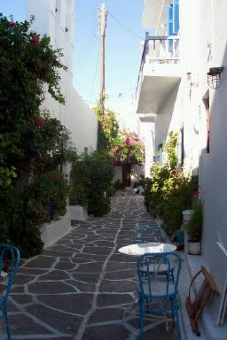
CYCLADEN EILANDEN - LES ISLES CYCLADES


Voor de volkeren uit de oudheid wormden de Cycladen een cirkel (kyklos) rondom het heiligdom Delos. De honderden eilanden en eilandjes liggen als fijn wit stof op de golven van de Egeïsche Zee, tussen het vasteland en Kreta. De pure en zuivere schoonheid van de deze toch dorre eilanden straalt onder de felle zon. Het schitterende wit van de dorpjes tekent zuivere lijnen tegen de okerkleurige rotswanden van kliffen en bergen. Sommige eilanden als Santorini, Folegandros en Milos zijn getekende door vulkanische verschijnselen en hebben verbazingswekkende landschappen. Lange tijd waren de Cycladen een arme streek, maar nu vormen ze al zo'n dertig jaar een belangrijk toeristische bestemming. De eilanden behoren toe tot de regio van de Zuid-Egeïsche Eilandengroep. Samen vormen ze een nomos (vergelijkbaar met een provicie). De hoofstad is Ermoupoli (Syros). Heel wat hoofdsteden op de eilanden dragen dezelfde naam als het eiland en worden door de inwoners Chora (stad) genoemd. De eilanden zijn onderverdeeld in drie groepen : de centrale Cycladen (Amorgos, Anafi, Antiparos, Folegandros, Ios, Naxos, Paros, Santorini, Sikinos, Syros), de westelijke Cycladen (Kea, Kimolos, Kythnos, Milos, Serifos, Sifnos) en de noorelijke Cycladen (Andros, Delos, Mykonos,Tinos). Daarnaast omvat de archipel ook nog tientallen kleine eilanden en duizenden riffen.
For the people in het older age, the Cyclades where forming a circle (kyklos) around the sanctuary of Delos. The hundred of islands and islets lying as fine white dust on the waves of the Aegean Sea, between the mainland and Crete. The sheer beauty and purity of these barren islands still shines under the bright Sun .The brilliant white of the villages draw clear lines against the ochre cliffs of mountains and cliffs. Some islands like Santorini, Folegandros and Milos are signed by volcanic phenomena and have amazing scenery. Long time the Cyclades a poor region, but now they are all around thirty years a major tourist destination. The islands belong to the region of the southern Aegean islands. Together they form a prefecture (similar to a province). The capital is Ermoupoli (Syros). Many cities in the islands bear the same name as the island and its inhabitants are Chora (town) called. The islands are divided into three groups: the central Cyclades (Amorgos, Anafi, Antiparos, Folegandros, Ios, Naxos, Paros, Santorini, Sikinos, Syros), the Western Cyclades (Kea, Kimolos, Kythnos, Milos, Serifos, Sifnos) and the actual northern Cyclades (Andros, Delos, Mykonos, Tinos). In addition, the archipelago also includes dozens of small islands and thousands of reefs.
SANTORINI


Santorini is de meest indrukwekkenste eiland van de Cycladen en ligt in het zuiden. Dit eiland overslaan is eigenlijk geen optie. De tocht per boot en de caldeira - de krater die duizenden jarne geleden door de golven werd overspoeld - is onvergetelijk. Na een gigantische vulkaanuitbarsting stortte de zee zich namelijk in de natuurlijk keteldal. Dat is omringd door gigantische kliffen die alle kleuren van de vulkanische gesteenten aannemen : het zwart van de lava, paargrijs van de as, rood van de vulkanische slakken, lichtgrijs van de puimsteen. Hoog op de bergen schitteren de witte dorpjes zadat het lijkt of ze met sneeuw bedekt zijn. De gigantische caldeira is half gesloten. Heir en daar herinneren vulkaankegels aan de geweldige nauutrramp die het eiland in de minoïsche periode trof en een historische aardverschuiving teweegbracht. Het eiland ligt op de scheiding van de tekonische aardlagen en werd als gevolg van de vulkaanuitbarstingen in vijf stukken gebroken, waardoor in het westen kliffen van 200 tot 400 m hoogte ontstonden, en in het oosten zachte hellingen van zwarte lava. Let op de haven van Athinios bevindt zich 10 km ten zuiden van de hoofdstad Thira, ongeveer halverwege de caldeira.
Santorini is the most impressive island of the Cyclades, situated in the south. Skipping this island is not really an option. The trip by boat and the caldera - the crater who was flooded a thousands years ago by enormous waves- is unforgettable. After a massive volcanic eruption collapsed sea into a the natural basin. It is surrounded by huge cliffs, whom take all the colors of the volcanic rocks: black of the lava, purple gray as the ash, red as the volcanic slag, light gray as the pumice. High on the hills shine the white villages, it looks like they are covered with snow. The huge caldera is half closed. Here and there, remember the big volcanic cones the natural disaster, the island had to undergo during the Minoan period and hit a historic landslide. The island lies on the separation of tekonian strata and as a result of volcanic eruptions the island broke into five pieces. In de west cliffs of 200-400 m were created, and in the east, slopes of soft black lava. There is also a port 10 km south of the capital Thira, halfway in the caldera.
Toeristische plekjes - Toeristic attractions
Thira


The capital of the island lies on the edge of the abyss in a wonderful setting. After the earthquake of 1956 the city was rebuilt, and it therefore has less charm than Oia. Yet the views of the caldera, the layered volcanic cliffs, the islands of lava and giant sea indescribable. From this point seem the passing ferries tiny boats.
 Deze hooggelegen weg biedt een duizelingwekkend uitzicht op de caldeira en op de mooie terrasvormige gewasculturen op het platteland. Net als Thira ligt Oia op een klif, maar het is er rustiger. Het uitzicht op de halvemaan van Santorini, die ankerplaats en de vulkanische eilandjes zijn prachtig. In dit typisch Cycladische dorp staan zeer oude pastelkleurige huizen, patriciërswoningen en witte kerken waarvan sommige een blauwachtige koepel hebben. Oia staat uit vijf kleine gehuchten, namelijk Ammoudi, Armeni, Tholos, Oia zelf en Finoikia. Ammoudi was aan het einde van de 19de eeuw een welvarende stad. Een honderdtal boten deed de haven aan, wat zorgde voor handelactiviteiten in het volledige oostelijke Middellandse Zeegebied. De rijkdom uitte zich in mooie kerken, weelderige huizen en pleintjes die werden versierd met marmer.
 This elevated road offers a dazzling view of the caldera and the beautiful terraced cultures in the country. Like Thira, Oia is located on a cliff, but it is quieter. The view of the crescent of Santorini, that anchorage and the volcanic islands are beautiful. In this typical Cycladic village are very old pastel houses, mansions and white churches, some of which have a bluish dome. Oia is five small hamlets, namely Ammoudi, Armenia, Tholos, Oia itself and Finoikia. Ammoudi was at the end of the 19th century a prosperous city. A hundred boats opened the port, which caused trading activity in the whole eastern Mediterranean. The wealth was expressed in beautiful churches, lush courtyards and houses that were decorated with marble.

De hoofdstad van het eiland ligt aan de rand van de afgrond in een uitzonderlijk mooie omgeving. Na de aardbeving van 1956 werd de stad heropgebouwd, en ze heeft daarom minder charme dan Oia. Toch is het uitzicht op de caldeira, de gelaagde vulkanische kliffen, de eilandjes van lava en de gigantische zee onbeschrijfelijk mooi. Vanaf deze plek lijken de voorbijvarende ferry's minuscule bootjes.

The capital of the island lies on the edge of the abyss in a wonderful setting. After the earthquake of 1956 the city was rebuilt, and it therefore has less charm than Oia. Yet the views of the caldera, the layered volcanic cliffs, the islands of lava and giant sea indescribable. From this point seem the passing ferries tiny boats.
Benedenstad - Downtown Thira
 De benedenstad is een wirwar van steegjes die tegen het klif aanliggen. Door de terrasvorm lijkt het wel een waterval van huizen. U ziet twee witte kerken : Agios Ioannis en Agios Minas, met een mooie koepel.
 De benedenstad is een wirwar van steegjes die tegen het klif aanliggen. Door de terrasvorm lijkt het wel een waterval van huizen. U ziet twee witte kerken : Agios Ioannis en Agios Minas, met een mooie koepel.
The downtown is a maze of alleyways that lie against the cliff. The terrace seems like a waterfall of houses.
You will see two white churches: Agios Ioannis and Agios Minas, with a beautiful dome.Oia
 Deze hooggelegen weg biedt een duizelingwekkend uitzicht op de caldeira en op de mooie terrasvormige gewasculturen op het platteland. Net als Thira ligt Oia op een klif, maar het is er rustiger. Het uitzicht op de halvemaan van Santorini, die ankerplaats en de vulkanische eilandjes zijn prachtig. In dit typisch Cycladische dorp staan zeer oude pastelkleurige huizen, patriciërswoningen en witte kerken waarvan sommige een blauwachtige koepel hebben. Oia staat uit vijf kleine gehuchten, namelijk Ammoudi, Armeni, Tholos, Oia zelf en Finoikia. Ammoudi was aan het einde van de 19de eeuw een welvarende stad. Een honderdtal boten deed de haven aan, wat zorgde voor handelactiviteiten in het volledige oostelijke Middellandse Zeegebied. De rijkdom uitte zich in mooie kerken, weelderige huizen en pleintjes die werden versierd met marmer.
 This elevated road offers a dazzling view of the caldera and the beautiful terraced cultures in the country. Like Thira, Oia is located on a cliff, but it is quieter. The view of the crescent of Santorini, that anchorage and the volcanic islands are beautiful. In this typical Cycladic village are very old pastel houses, mansions and white churches, some of which have a bluish dome. Oia is five small hamlets, namely Ammoudi, Armenia, Tholos, Oia itself and Finoikia. Ammoudi was at the end of the 19th century a prosperous city. A hundred boats opened the port, which caused trading activity in the whole eastern Mediterranean. The wealth was expressed in beautiful churches, lush courtyards and houses that were decorated with marble.
Akrotiri
Deze antieke stad dateert uit de bronstijd, dus voor de grote vulkaanuitbarsting. Net als Pompeij werd ze bedolven onder een dikke laag ondoordringbare as. De stad werd in 1967 ontdekt door professor Marinatos die in 1974 stierf bij een ongeval. Er werden heel wat ontdekkingen gedaan, onder meer de fresco's die nu in het museum van Thira te bewonderen zijn. Akrotiri bleef na de geweldige natuurramp op wonderbaarlijke wijze bewaard. Bezoekers worden verrast door de straatjes, betegelde pleintjes en de huizen met twee etages waarvan de trappen, deuren en vensters gedeeltelijk origineel zijn. De grote vazen (Pithoi) waarin etenwaren werden bewaard, staan nog op de plek waar ze werden gevonden. De historische stad werd waarschijnlijk door haar inwoners verlaten door de aardbeving, aangezien er geen lichamen werden gevonden. Akrotiri is momenteel gesloten omdat er een ongeval met een toerist gebeurde tijdens het bezoek aan de stad. This ancient city dates from the bronze age, so just before the major volcanic eruption. Like Pompeij, is the town buried under a thick layer of impermeable ash. Founded in 1967 discovered by Professor Mari Atos who in 1974 died in an accident. There were many discoveries, including the frescoes, you can admire these fescoes in the Museum of Thira. Akrotiri remained after the great natural disaster miraculously preserved. Visitors are surprised by the streets, paved squares and houses with two floors, including stairs, doors and windows partially original. The large vases (Pithoi) where food was stored, are still where they were found. The historical city was probably abandoned by its inhabitants by the earthquake, as no bodies were found. Akrotiri is currently closed because of an accident involving a tourist happened during the visit to the city.
PAROS


Paros is een uitgestrekt eiland met veel natuurgebieden en monumenten. Het is beroemd om zijn zeer fijn wit marmer, dat het eiland lange tijd welvarned maakte. Het eiland bezit ook uitstekende ankerplaatsen en gunstige winden die menig surfer en zeiler kan bekoren. Het op drie na grootste eiland van de Cycladen is tevens het belangrijkste maritieme kruispunt van de archipel. Paroikia is tegerlijkertijd de haven en de hoofdstad van het eiland. In het noorden ligt het piepkleine haventje van Naoussa, dat in de zomer een levendige badplaats is. De mooiste stranden bevinden zich aan de oostkust.
Paros is a large island with many natural areas and monuments. It is very famous for its fine white marble; the island has long history in the marble industry. The island also possesses excellent anchorages and favourable winds that may tempt surfers and sailors. Paros is the fourth largest island of the Cyclades is also the most important maritime crossroads of the archipelago. Paroikia not only is the port but also capital of the island. In the north lies the tiny port of Naoussa, which in summer is a lively seaside resort. The best beaches are located on the east coast.
Toeristische plekjes - Toeristic attractions
Paroikia

De hoofdstad van het eiland is een belangrijke havenstad waar dag en nacht ferry's aankomen uit de gehele Egeïsche Zee. Reizigers op doorreis zien van het eiland alleen de beroemde molen in de buurt van de aanlegplaats. Vrachtwagens, wagen, scooters en voetgangers verdringen zicht hier in een onbeschrijflijke wanorde, terwijl uit de bars in de omgeving oorverdovende muziek klinkt. De boulevard aan de rechterkant, benende aan de kastro, is eveneens zeer druk maar des te gezelliger. Even verderop liggen de stalende witte steegjes van het dorp. Paroikia werd gebouwd op de plaats van de historische stad. De overblijfselen daarvan zijn nog te zien in een afgesloten gebeid, enkele meters voorbij de haven. Het stadje bestaat uit een twee duidelijk verschillende delen. Links van de aanlegsteiger ligt het nieuwe stadsgedeelte Livadia en rechts ligt de historische stadsgedeelte met boven aan een klein Venetiaans fort.
 Paroikia the capital of the island is an important port, day and night ferries arrive from across the Aegean Sea. Passengers in transit , will only see de famous windmill on the island near the dock. Trucks, cars, scooters and pedestrians crowd here in an indescribable disorder, whereas the bars nearby, play deafening music. The boulevard on the right, near the Kastro is also very busy, but all the more enjoyable. A little further on, are the sparkling white streets of the village. Paroikia was built on a historicale site of the island. The remains are still visible in a closed area, a few meters away from the harbor. The city can be divided into two distinct parts. Left of the jetty lays the new town Livadia and the right is the historic town, on the highest point a small Venetian fortress.
Naoussa

Deze aardige kleine vissershaven ligt beneden aan het volledig witte dorp dat zich op de heuvelheelling uitstrekt, rondom de grote parochiekerk. De smalle steegjes badne in het licht, zelfs 's nachts, want in de zomer slaapt het dorp nooit. Toch heeft de haven met zijn talrijke en kleurrijke Kaïks en visrestaurantjes zijn authenticitiet bewaard. Het is er heerlijk eten op de terrassen die worden beschaduwd door zeildoek en waar de inktvissen liggen te drogen in de zon. Even verderop staat het kleine Venetiaanse fort dat gedeeltelijk onder water ligt.
KRETA


Toeristische plekjes - Toeristic attractions


Geen opmerkingen:
Een reactie posten